Disaster Resilience Index and Indicators System for Managing Risks in Hazardous Project Terrain (DiRIMS)
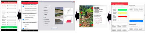
Published on Wednesday, July 8, 2020Disaster Resilience Indicators Management System (DiRIMS) is a decision support system designed for slope stability and asset as example transmission tower. DiRIMS has been designed to improve current slope monitoring method by producing a slope rating at every transmission tower. One of the unique features of DiRIMS is that it creates a specific symbol and sound that can alert and notify users about the slope/tower condition. Alert status for each transmission tower such as low, slight and moderate potential failure will be displayed at each slope/tower. In addition to the alert status, prevention and mitigation measures including costing for maintenance purpose will also be display and advice for each slope/tower.
DiRIMS produce the slope stability result for each tower slope by reading the input slope data and matching it automatically with a specific parameter. A chart will be generated to summarize the overall tower slope status (low, slight and moderate potential) by displaying the total numbers according to its status.
DiRIMS also can be link with various applications such as Geographic Information System (GIS) or Google Earth to shows the location of the slope/tower in which category of hazard risk. This will develop a risk-communication and stakeholder-led participatory process for choosing the prevention and mitigation measures that are most appropriate from the technical, economic, environmental and social perspectives.
Project leader: Assoc. Prof. Dr. Rohayu Che Omar